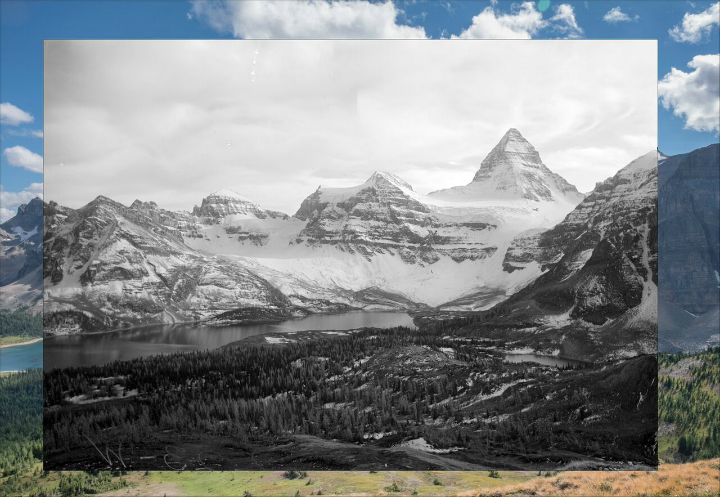
Mt. Assiniboine and Magog Lake from below “The Nub”. Historic image taken by Arthur Wheeler in 1913 as part of the Inter-Provincial Boundary Survey. Photo courtesy Mountain Legacy Project and Library and Archives Canada.
University of Victoria researchers are raising alarms of climate change impact based on 150 years of mountain landscape pictures.
The Mountain Legacy Project has documented ecological and cultural changed through historic pictures taken from mountain surveyors from 1861 to 1958.
Modern cameras have been used to capture images of the same vistas in exactly the same locations.
Comparing the results shows a big change between the historic and recent photos.
Mt. Assiniboine and Magog Lake from below “The Nub”. Historic image taken by Arthur Wheeler in 1913 as part of the Inter-Provincial Boundary Survey. Photo courtesy Mountain Legacy Project and Library and Archives Canada.

The modern photo, taken at the same location as the Wheeler 1913 image (Mt. Assiniboine and Magog Lake from below “The Nub”) in Mt. Assiniboine Provincial Park, was captured as part of an outreach project between the MLP and the Alpine Club of Canada – Vancouver Island section. Photo courtesy MLP and M.E. Sanseverino.
“We now have more than 7,000 repeat pairs of images gathered over 19 summers working with graduate and undergraduate students,” UVic environmental scientist Eric Higgs said, who leads the project.
“People can clearly see the significant changes brought about by a shifting climate, human activity and development, and ecological processes.”

The Athabasca Glacier in Jasper National Park. Photos making up this panorama were taken by Arthur Wheeler in 1917 as part of the Inter Provincial Boundary Survey. Photo courtesy MLP and Library and Archives Canada.

The modern photos, taken at the same location as the Wheeler 1917 image Athabasca Glacier in Jasper National Park, in this panorama were captured by the 2011 MLP field team. Photo courtesy Mountain Legacy Project
The Mountain Legacy Project moved the UVic’s School of Environmental Studies in 2002 when Higgs was appointed as director.
It originated at the University of Alberta in 1998.

Bull Creek looking west into the Highwood Ranges in south western Alberta. The historic images were taken by David Nichols in 1916 as part of a map-making survey in Kananaskis Country. Photo courtesy MLP and Library and Archives Canada.

The modern photo, taken at the same location as the Nicols 1916 image (Bull Creek looking west into the Highwood Ranges), was captured in 2012 by an MLP field team. Photo courtesy Mountain Legacy Project.

Mt. Sir Donald and the Illecillewaet Glacier in BC’s Glacier National Park. Photos making up this panorama were taken by Arthur Wheeler in 1901 as part a map-making survey of the Selkirk Range adjacent to the Canadian Pacific Railway. Photo courtesy MLP and Library and Archives Canada

The modern photos, taken at the same location as the Wheeler 1901 image (Mt. Sir Donald and the Illecillewaet Glacier), in this panorama were captured in 2011 by an MLP field team from the ridge of Mt. Abbott. Photo courtesy Mountain Legacy Project.

